On May 20, 2012, for the first time in 26,000 years, the Sun and Moon, and the constellation responsible for our spiritual evolution and ascension, the mystic Pleiades, will align in a spectacular, full Annular Solar Eclipse and a rare solar eclipse alignment will happen between the Earth, the Sun and, our central Sun, Alcyone in the Pleiades Constellation.
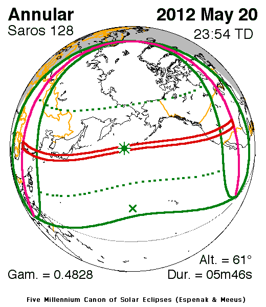
An annular solar eclipse occurs when the Moon's apparent diameter is smaller than the Sun, causing the Sun to look like an annulus (ring), blocking most of the Sun's light. An annular eclipse appears as a partial eclipse over a region thousands of kilometres wide.
The annular phase will be visible from the Chinese coast, northern Taiwan, the south of Japan, and the western part of the United States and Canada. Guangzhou, Taipei, Tokyo and Albuquerque will be on the central path. Its maximum will occur in the North Pacific, south of the Aleutian islands for 5 min and 46.3 s, and finish in the western United States.

Times and locations of full and partial sightings
:http://www.timeanddate.com/eclipse/solar/2012-may-20
:http://www.timeanddate.com/eclipse/solar/2012-may-20
“The Pyramid of the Sun outside Mexico City at Teotihuacan is said to be aligned with the Pleiades,  for its west face and many of the surrounding streets were aligned directly with the setting point of the Pleiades on midnight of the night when it is at its highest point. The Pleiades was clearly revered also by the Mayans, who in the area of Chichen Itza knew that the Sun casts a snake-like shadow on the side of the north stairway of the Kukulcan pyramid during the spring equinox. Some scholars have calculated that about 60 days after this shadow’s appearance, when the sun reaches its zenith over the Pyramid at mid-day (May 20 – May 23), there is another direct alignment with the Pleiades. This Pleiades-sun alignment may have a direct connection with Quetzalcoatl, the feathered serpent that came to bring a greater wisdom to the planet.
for its west face and many of the surrounding streets were aligned directly with the setting point of the Pleiades on midnight of the night when it is at its highest point. The Pleiades was clearly revered also by the Mayans, who in the area of Chichen Itza knew that the Sun casts a snake-like shadow on the side of the north stairway of the Kukulcan pyramid during the spring equinox. Some scholars have calculated that about 60 days after this shadow’s appearance, when the sun reaches its zenith over the Pyramid at mid-day (May 20 – May 23), there is another direct alignment with the Pleiades. This Pleiades-sun alignment may have a direct connection with Quetzalcoatl, the feathered serpent that came to bring a greater wisdom to the planet.
The ancient Egyptians also singled out the Pleiades as a female goddess, probably most often recognized as Neith, the “divine mother”, or Hathor, who took on the form of a cow (who carried the seeds of life). Pyramidologists working in Egypt in the last twelve years have found pyramidal texts that suggest the Egyptians revered the Pleiades as a higher divine star system, especially Alcyone, its brightest star.”